Cyclone Senyar and Ditwah: Recently discussed Cyclone Ditwah and Cyclone Senyar have created concern for India. A rapidly changing weather system caused by the remnants of Cyclonic Storm “Ditvah” and Cyclone “Senyar” is affecting large parts of India, especially the southern and coastal areas.
Read :- Cyclone Shakti Live Tracking: Cyclone ‘Shakti’, the first storm of 2025, is forming in the Arabian Sea, IMD’s alert issued.
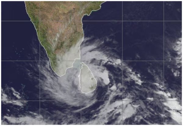
According to the latest bulletin of the India Meteorological Department (IMD), Cyclone Ditwah, which was earlier a deep depression, is currently over the Sri Lankan coast and the adjoining southwest Bay of Bengal. The system is moving in a north-northwest direction, and is expected to reach near the coasts of North Tamil Nadu, Puducherry and South Andhra Pradesh by the morning of 30 November.
Meanwhile, the remnant of Cyclone Senyar has weakened into a low pressure area over the Malacca Strait, but its impact, coupled with the intensification of Ditwah, is creating unstable conditions over the Bay of Bengal and surrounding areas.
The impact of both cyclones is causing heavy to very heavy rainfall in many southern states, with Tamil Nadu experiencing the worst weather. The IMD has warned of very heavy rainfall at some places on November 28 and 29, especially in districts where the soil is already waterlogged and wet. Rayalaseema and coastal Andhra Pradesh are also on alert, very heavy rainfall may occur on November 30, when the system will move close to the coast.
Heavy rain is also expected in parts of Kerala, Mahe, Telangana and Karnataka, although the intensity of rain in these areas is expected to be more local. Over South Interior Karnataka, rainfall is likely to be heaviest around November 29, while Telangana may see heavy rainfall around November 30 and December 1. The intensity and spread of rainfall is being closely monitored due to the increased possibility of flash floods and inundation of cities.
Read :- UP Rain Alert: Cyclonic storm is coming! Impact will be visible on many states including UP-Bihar
As of 28 November, low to moderate flash flood risk has been reported in several districts of Tamil Nadu and Puducherry, including Kanyakumari, Ramanathapuram, Tirunelveli and Tuticorin. The storm is expected to continue over Tamil Nadu and Coastal Andhra Pradesh till December 1. Similar conditions will remain in Kerala and Mahe till 29th November. IMD has warned that there is a high risk of lightning during this period, especially in coastal and low-lying areas. Andaman and Nicobar Islands are also experiencing disturbed conditions with squally winds with speed reaching 30-40 km/hr on 28th and 29th November.
While South India is experiencing cyclonic rains, the weather pattern is completely different in parts of North India. The minimum temperature in northwest India is expected to rise gradually by 2-3 degrees Celsius in the next two days, after which it will decline. Dense fog is expected in parts of Himachal Pradesh and Haryana-Chandigarh-Delhi region from 28 to 30 November.
Dense fog is also expected in East Rajasthan between November 30 and December 1, while cold wave will prevail in Punjab on November 28 and 29. There will be cold wave conditions again in Rajasthan on 3rd and 4th December. On the contrary, Central India will see a slight drop in the minimum temperature in the next two days. The weather in eastern India is likely to become slightly warmer in the next three days with minimum temperatures increasing by 2-3 degrees Celsius.
Contact to : xlf550402@gmail.com
Copyright © boyuanhulian 2020 - 2023. All Right Reserved.