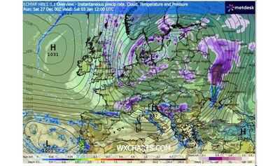

The UK could be in store for snow and cold weather at the start of 2026. The latest weather maps from WX Charts show snow sweeping in from the East with the Met Office expecting "wintry hazards" in the first part of January.
The maps show patches of snowfall arriving in Scotland and the North east coast of England at 12am on Saturday, January 3. Further flurries of wintry weather will continue to pass through the UK until 12am on Wednesday, January 7, totalling 96 hours of snowfall.
In its long-range forecast from Wednesday, December 31 until Friday, January 9, the Met office says cold air will result in wintry weather while temperatures are expected to drop lower than average.
According to WX Charts, parts of Scotland and England, including Newcastle, Leeds and Norwich will see snowfall at 12pm on Saturday, January 3. The heaviest flurries will be in the North East, with up to 20mm expected to fall per hour.
The snow will then continue into the start of the following week, with flurries forecast across the Midlands. A map from WX Charts shows up to 20mm falling per hour across the region at 6pm on Monday, January 5.
Some snow will remain on the following day with WX Charts showing flurries in eastern areas of England. The maps show up to 20mm per hour falling in Colchester and Ipswich at 12pm on Tuesday, January 6.
The Met Office forecast for the period explains there will be "low pressure to the east" as well as low pressure moving through the North Sea. This could bring wintry weather to the UK.
The forecaster states: "With cold air close to the UK, some wintry hazards are possible in places."
It adds: "Temperatures will probably be below average for this period overall and so wintry hazards remain a possibility in places."
In its forecast from Saturday, January 10 until Saturday, January 24, the Met Office is predicting an "enhanced risk of wintry hazards affecting some parts". However, temperatures are expected to increase to above average.
The Met Office says: "Temperatures will likely recover a little to be near to or slightly below average during this time, but an enhanced risk of wintry hazards affecting some parts at times remains. Later in the period, a transition to more widely changeable or unsettled conditions is possible, with a corresponding shift to near or slightly above average temperatures."
It was previously reported that much of England, Wales, and Scotland will see snow on Monday, January 5. Weather maps showed some areas seeing as much as 13cm of snow depth.
Snow depth in England looks set to range from between around 1cm to 6cm south of Newcastle, with Wales seeing around 1cm, the weather site's maps indicate. In Scotland, snow depth could range from 1cm to 13cm around were the southeastern edge of the Highlands meets Aberdeenshire and Perth and Kinross.
Contact to : xlf550402@gmail.com
Copyright © boyuanhulian 2020 - 2023. All Right Reserved.