Dushanbe [Tajikistan], February 13 (ANI): An earthquake of magnitude 4.2 struck Tajikistan, as per a statement by the National Centre for Seismology (NCS).
The earthquake occurred at a depth of 100km.
In a post on X, the NCS said, "EQ of M: 4.2, On: 12/02/2026 20:35:18 IST, Lat: 37.81 N, Long: 72.55 E, Depth: 100 Km, Location: Tajikistan."
Earlier, on February 10, an earthquake of magnitude 4.4 struck the region at a depth of 108km.
In a post on X, the NCS said, "EQ of M: 4.4, On: 10/02/2026 07:23:50 IST, Lat: 37.44 N, Long: 72.02 E, Depth: 108 Km, Location: Tajikistan."
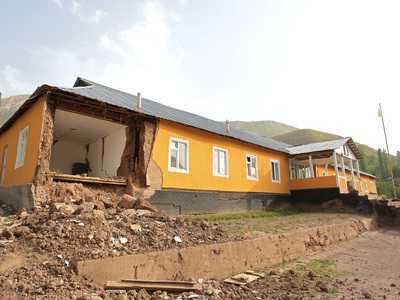
Tajikistan is a mountainous country with diverse topography and is especially vulnerable to climate hazards. It is prone to earthquakes, floods, droughts, avalanches, landslides and mudslides. The most susceptible areas are the glacier-dependent river basins supplying hydropower and water resources for irrigation, fragile mountain ecosystems and isolated forests with mountainous and riverine terrain, which makes them prone to landslides and land degradation.
As per the World Bank Climate Change Knowledge Portal, climate change is exacerbating Tajikistan's vulnerabilities, given that 30 per cent of glaciers are predicted to disappear by 2050. Tajikistan also remains one of the most isolated countries in the world - a situation made worse by landslides, debris flows and floods that can render bridges unsafe and roads impassable and, through time, weaken the flood defences which protect its most exposed communities.
In addition to this chronic challenge, Tajikistan's infrastructure is gradually deteriorating as a result of insufficient maintenance and repeated exposure to natural hazards.
As per the Global Facility for Disaster Reduction and Recovery, it is important to blend hazard information and climate change scenarios with local knowledge in the design of newly constructed and rehabilitated infrastructure assets to improve resilience over time. (ANI)
Contact to : xlf550402@gmail.com
Copyright © boyuanhulian 2020 - 2023. All Right Reserved.