Britain may be preparing for an unexpected late-season snowfall within days.
Recent weather maps indicate wintry conditions are set to arrive from May 3, with snowflakes initially appearing around midday before extending across up to 17 counties by the evening of May 7.
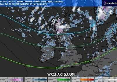
The most recent charts from WXCharts, drawing on MetDesk data, reveal a frosty outlook - with areas of Scotland particularly vulnerable.

By midnight on May 4, the snow showers are anticipated to strengthen, with the Highlands and Argyll and Bute experiencing heavier, more sustained flurries. Temperatures are also forecast to plummet sharply, with predictions showing lows of -3C as the cold spell takes hold.
Maps produced on April 25 demonstrate the mercury dropping as freezing conditions persist.
While the Met Office's long-range forecast for April 29 to May 8 makes no reference to snow, it does caution that conditions may become progressively unsettled, with showers and extended periods of rain expected to prevail at times.
It reads: "High pressure is likely to lie close to the UK at the start of this period.
"Most places will be dry with sunny spells and light winds, although there could be some overnight mist and fog. Into the first week of May, conditions will probably become more changeable with low pressure systems becoming more likely.
"This means an increasing chance of showers or longer spells of rain, with a risk of strong winds at times. Temperatures are likely to be close to or slightly above normal." The Met Office has previously outlined why Britain's snow forecasts prove more complicated than those across continental Europe, owing to rapidly-changing conditions.
"Small variations in temperature or wind direction can mean the difference between rain, sleet or snow," its website said. "Meteorologists use high-resolution models to predict precipitation type, but these models can struggle with marginal situations where temperatures hover around freezing.
"Forecasters also consider factors such as precipitation intensity. Heavy bursts of precipitation can cool the air near the surface, increasing the chance of snow. Conversely, lighter precipitation may melt before reaching the ground. This fine balance makes snow forecasting one of the most uncertain aspects of UK weather prediction."
- Perth and Kinross
- Highlands
- Argyll & Bute
- Angus
- Dundee city
- Stirling
- Clackmannanshire
- Falkirk
- West Lothian
- Aberdeenshire
- Fife
- Lanarkshire
- East Ayrshire
- North Ayrshire
- South Ayrshire
- Dumfries and Galloway
Contact to : xlf550402@gmail.com
Copyright © boyuanhulian 2020 - 2023. All Right Reserved.